Showing posts with label Walk Across America. Show all posts

Friday, December 31, 2010

Walk Across America–Day 14

Today I exercised for 57 min = 57 miles (total = 743mi) and arrived in Irvine, KY
Irvine_ky1
It was built on land once granted to Green Clay. It was founded on January 28, 1812 and named for William Irvine, an early settler and Indian fighter. The town did not incorporate until 1849, and was ransacked on October 13, 1864 by Confederate guerrillas, who burned the jail.  The town remained small until the 1870s, when its population passed 300. Construction of the Louisville & Nashville Railroad's North Fork through town, as well as a coal boom around the turn of the century, greatly increased the local population. Irvine annually hosts the Mountain Mushroom Festival on the last weekend of April. Irvine, along with the nearby city of Ravenna, are known as the "Twin Cities

Thursday, December 30, 2010

Walk Across America–Week 2 & 3

December 19-25 – Week 2
I was sick and needed to rest my body so I didn’t exercise much… but by the end of the week I had gone 90 miles (total of 446miles) and made it to Sugar Grove, VA
mailedD4
The grove of sugar maple trees along the banks of Cressy Creek is where Sugar Grove derives its name. Sugar Grove is called "The Head Springs Of The South Fork Of The Holston River"...and is one of the first places settled on the Holston River.

December 26- 30 – Week 3
still not feeling 100%, but I am exercising my normal routines again :)  So by the 30th I had gone another 240 miles (total of 686) and got into Kentucky!  Booneville, KY
booneville_20070109190954

The town was named for American frontiersman, Daniel Boone. The town, consisting at the time of little more than a temporary log courthouse, became the county seat when Owsley County was formed on May 20, 1844. During the Civil War, Booneville was a crossroads for various Union and Confederate regiments, and was threatened by Confederate guerrillas, but avoided the destruction that befell some other county seats of Kentucky during the war.

Saturday, December 18, 2010

Days 5 & 6 – Walk Across America

I didn’t get a chance to post here about my walk yesterday… so I am doing double duty today :)

12/17 – I walked 40 min = 40 miles to arrive in Buchanan, VA. (292 miles from my starting point)
IMG_0050rnt
On June 14, 1864, after occupying Lexington and burning the Virginia Military Institute, Union General David Hunter's 18,000-man force marched south toward Lynchburg through Buchanan, a river port located at the western terminus of the James River and Kanawha Canal. When Union General William W. Averell's cavalrymen attempted to seize the Buchanan Bridge across the James River, Confederate General John C. McCausland's troopers who had been harassing them, confronted them again. By the time Averell arrived, the Confederates had packed the wooden covered bridge with coal oil-soaked hay. McCausland ignited the north end of the bridge then escaped in a small boat to the side of the river, corssing beneath the burning structure. An artillery duel ensued. The wind carried embers from the bridge across the river to dwellings in Pattonsburg. Averell's men helped extinguish the flames, but not before eleven houses burned. The bridge, which survived the fire, was unusable, so Union soldiers, wagons, and artillerg forded the river upstream, losing a day's march. The next morning, Hunter's force crossed the Blue Ridge Mountains on present-day Route 43. (background information taken from Civil War History Marker located at the Bridge) The old bridge piers today support the pedestrian swinging bridge.

12/18 – Walked 64 min = 64 miles and arrived at the Wilson Creek Bridge near Ellett, VA (356 miles total)
Wilson_creek_bridge
The Wilson Creek Bridge (also known as the Smart Road Bridge) is the tallest bridge in Virginia at 175 feet (53 m) tall.  The cast-in-place cantilever box girder bridge design is the only one of its kind in Virginia. The bridge is hollow. Beneath the riding surface, the box girders are open with a width of 18 feet (5 m) and a height which varies from 12 feet (4 m) to 35 feet (11 m). Power and communication lines are carried in the hollow concrete box and run the length of the bridge. Manholes in the bridge deck allow researchers to enter the box to monitor testing equipment. The support structure of the bridge is inlaid with Hokie Stone to blend in with the environment and meld with the architectural stylings of Virginia Tech.

Thursday, December 16, 2010

Day 4 – Walk Across America

12/16/10 – walked 62 min = 64 miles and arrived in Vesuvius, VA.  252 miles from Yorktown, Va where I started :)September
The Village of Vesuvius dates its existence back to 1828, when the Vesuvius Furnace was built. The Vesuvius Foundry, which made plows and farm implements, began operations in 1843. The Village began to bustle when the Shenandoah Valley Railroad came through in 1882. The Vesuvius Post Office followed and the village soon became the center for commerce in the northeast corner of Rockbridge County.

Wednesday, December 15, 2010

Day 3 – Walk Across America

Today I walked 64min = 64 miles and arrived at the Mechums River in Virginia which is about 11 miles outside of Charlottesville.
img_1542
The Mechums River is a short tributary of the South Fork of the Rivanna River in central Virginia in the United States. Via the Rivanna and James Rivers, it is part of the watershed of Chesapeake Bay

Tuesday, December 14, 2010

My Walk Across America, virtually of course ;)

So, in my web browsing, I came across a site where you could log in your time or miles walked during exercise and walk across America virtually.  So, I decided to make my exercise a little more fun and learn and see some of America along the way :)

I decided to use a ratio of 1 minute to 1 mile.  My journey started in Yorktown Virginia2598381337_440530bffa 
Yorktown is in York County, Virginia, United States. The population was 220 in the 2000 census. It is the county set of York County, one of the eight original shires formed in colonial Virginia in 1634.

The town is most famous as the site of the siege and subsequent surrender of General Cornwallis to General George Washington during the American Revolutionary War on October 19, 1781. Although it would last for another year, this British defeat at Yorktown effectively ended the war. Yorktown also figured prominently in the American Civil War (1861–1865), serving as a major port to supply both northern and southern towns, depending upon who held Yorktown at the time.

On the 13th I walked for 62 minutes = 62 miles and arrived in Elko, VA4452405644_eda157c370

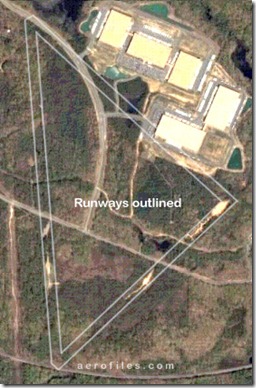
Elko Tract is a 2,220 acre (9 km²) tract of land in Henrico County, Virginia. It is considered one of Virginia's most well known ghost towns due to its history as a decoy airfield during World War II and suspicious activity in the area afterwards.

During 1943-44, the 1896th Engineer Aviation Battalion built a decoy airfield near the small town of Elko, VA. The decoy airfield was constructed 5 miles southeast of Richmond's Byrd Field, and it was arranged in an identical fashion, with 3 'runways' in the same orientation as Byrd Field. It was intended to protect Byrd Field by confusing enemy aircraft & drawing them away from their real target. According to James "Slim" Wilberger, the decoy airfield was equipped with working lights, as well as decoy airplanes, buildings and trucks constructed of plywood.
elkoAF-decoy

On the 14th I walked 64 min = 64 miles and arrived at Lake Anna about 11 miles outside of Mineral, VA.
ar123125743162255

Lake Anna is the second largest fresh-water inland lake in Virginia, with over 250 miles of shoreline and some 13,000 surface acres of water. Lake Anna has become Central Virginia's premier choice for water sports and fishing. Initially known as a vacation community, the number of full time residents has grown steadily since the lake was created in 1972.